

Estimated Reading Time: 7 minutes
When people think of Sardinia, they usually picture turquoise waters, white-sand beaches, and lazy days along the coast. The island is marketed as a Mediterranean paradise—sun umbrellas, sailing boats, and long seafood lunches by the sea.
But Sardinia’s true heart does not lie on the shoreline.
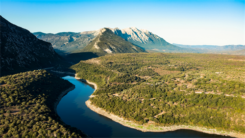
It lies inland, in a vast, rugged, and largely untamed mountain region known as Gennargentu National Park (Parco Nazionale del Gennargentu). This is a Sardinia most travelers never see—and one that demands far more than flip-flops and a casual itinerary.
A “Hardcore Minimalist” Hiking Experience
Hiking in Gennargentu could best be described as a contradiction: raw and demanding beneath a deceptively gentle Mediterranean surface.
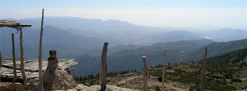
On first glance, the landscape feels welcoming—wildflowers, oak forests, clear streams, bright southern light. But once you step onto the trail, it becomes clear that this is not a leisurely walk through a manicured park. This is a place that tests your navigation skills, physical balance, and mental resilience.
Gennargentu is not beginner-friendly. It is best suited for experienced hikers who are comfortable with uneven terrain, offline navigation, route planning, and adapting to sudden changes. Trails often fade into shepherd paths, dry riverbeds, or bare granite slabs. You will not always know where the “official” path ends—and that is exactly the point.
Here, the trail is not designed for tourists.
It is the result of centuries of human and animal movement, carved by shepherds and their flocks rather than park authorities.
Not a Park You Visit—A Living System You Enter
What truly sets Gennargentu apart is this:
You are not visiting a scenic attraction. You are entering a living ecosystem that continues to function largely on its own terms.
There are no visitor centers every few kilometers, no cafés along the trail, no reliable phone signal. Waymarking is sparse, sometimes nonexistent. Weather, terrain, livestock, and wildlife are not background elements—they actively shape your journey.
Mountain weather can change rapidly. A sudden rainstorm in spring or autumn can transform a dry riverbed into a dangerous obstacle. In summer, heat and drought dominate, and biting flies can test your patience. And then there are the sheepdogs—massive white guardians bred to protect flocks. Encounters require calm, steady behavior and respect.
Planning here is not about control; it is about accepting uncertainty.
Who Should Not Come Here
If you are looking for paved paths, frequent signage, gentle viewpoints, and easy photo stops, Gennargentu will disappoint you.
This park is not suitable for families with young children, travelers with mobility limitations, people with a fear of heights, or those without prior hiking experience.
But if you are drawn to solitude, wild landscapes, ancient pastoral culture, and the quiet satisfaction of self-reliance, Gennargentu offers something increasingly rare in Europe: genuine wilderness.
Understanding the Trail System
Broadly speaking, hiking routes in Gennargentu fall into two categories:
1. Official Marked Routes
Managed by the Sardinian regional authorities, these trails have standardized codes (such as B-543 or D-305). They usually have identifiable trailheads and basic maintenance. These routes form the backbone of independent exploration.
2. Local and Guide-Led Routes
Many of the most spectacular paths are unmarked, hidden within gorges, forests, and high pastures. These routes are best accessed with a licensed local guide, who understands both the terrain and the unwritten rules of the land.
Piricanis Gorge: A Condensed Introduction to Gennargentu
For our visit, we chose the Piricanis Gorge, one of the park’s classic routes on its eastern side. The appeal lies in how much variety it packs into a relatively short distance.
We booked a guided hike in advance through platforms like GetYourGuide and carefully monitored weather conditions. Clear skies made for ideal hiking days.
Early in the morning, we drove from the mountain town of Arzana, reaching the trailhead after about 30 minutes on winding mountain roads. Although paved, the road is narrow and demanding. The starting point itself is easy to miss—without a guide or precise GPS data, it would be almost invisible.
Stage One: Reading the Riverbed
The hike begins in the bed of the Rio ’e Forru. This is not a flat stroll. You move across large rounded stones and smooth slate, constantly adjusting your footing and often hopping from bank to bank.
Even in the dry season, shallow crossings can soak your shoes. The sound of water becomes your main guide, while steep rock walls rise on both sides, creating an immediate sense of enclosure and seriousness.
Stage Two: Forest Immersion
Leaving the riverbed, the route dives into a dense forest of holm oak and turkey oak. Light fades, humidity increases, and the ground becomes soft with layers of decomposing leaves.
According to local guides, this area may be one of the last refuges of Sardinia’s endemic trout, making it ecologically significant as well as visually striking.
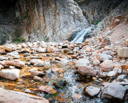
Stage Three: The Waterfall Reward
As the sound of water grows louder again, the destination comes into view. The Rio ’e Forru waterfall cascades down a vertical rock face into a clear pool below.
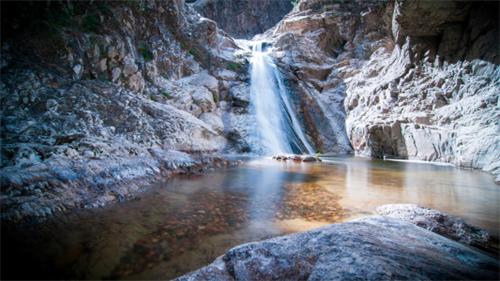
Expectations must be managed: between July and September, the waterfall may shrink to a trickle or dry up entirely. Yet even then, the amphitheater-like setting—sheer rock walls enclosing the space—remains powerful.
The route covers about 5 kilometers, with roughly 100 meters of elevation gain, officially rated as easy (E) and typically completed in three hours. That rating, however, assumes confidence on uneven and unpredictable terrain.
Two More Routes Worth Considering
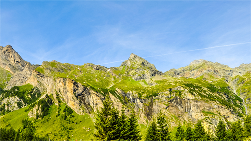
Genna ’e Mela Loop (B-543)
This 10.3-kilometer high-altitude forest loop starts at 1,280 meters above sea level and descends through woodland, crosses a river, and climbs back to the starting point.
It is one of the park’s more approachable routes and well-suited to a full day of quiet hiking. Wild herbs like thyme and helichrysum fill the air, and sightings of mouflon, wild boar, or golden eagles are possible.
Punta La Marmora
At 1,853 meters, Punta La Marmora is Sardinia’s highest peak. Routes vary, often starting near the town of Fonni, and involve sustained uphill walking on shepherd paths that can become indistinct.
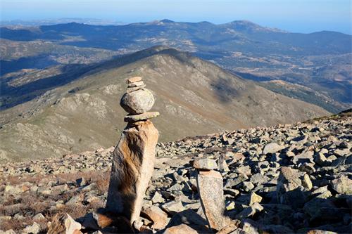
The reward is a 360-degree panorama: the Emerald Coast to the east, the Supramonte range to the west, and on clear days, Corsica visible to the north. This is a serious hike and not recommended solo.
Six Things Guidebooks Rarely Tell You
1. Weather Defines Everything
Spring and autumn bring dramatic water levels and lush scenery but increase river-crossing risks. Summer offers clearer routes but intense heat. Waterproof, ankle-supporting hiking boots are essential.
2. Navigation Is Non-Negotiable
Mobile signal is largely nonexistent. Download offline maps and GPX tracks, and carry a paper map and compass as backup.
3. You Must Be Fully Self-Sufficient
There are no shops, fountains, or shelters along the trails. In summer, plan for at least 3 liters of water per person, plus high-energy food.
4. Public Transport Won’t Get You There
A rental car is essential. Mountain driving is slow, narrow, and requires confidence.
5. Respect Pastoral Rules
Shepherds and their dogs are part of the landscape. Stay calm, keep distance, do not run, and allow dogs to assess you.
6. Embrace Imperfection
Route changes, delays, and unpredictability are not problems to fix—they are the essence of hiking here.
Practicalities: Transport, Cost, and Time
Transport: Fly into Cagliari or Olbia, rent a car, and drive 2–3 hours to gateway towns like Arzana or Desulo.
Costs:
- Budget: €80–120 per day (self-catering, basic accommodation)
- Comfort: €150–250 per day (guided hikes, hotels, dining)
Time:
- Minimum: 3 days / 2 nights
- Ideal: 5–7 days to explore multiple routes comfortably
Gennargentu vs. Madonie vs. GR20
Gennargentu’s defining concept is wild exploration.
Unlike Sicily’s Madonie Mountains, where hiking often intertwines with historic villages and archaeological sites, or Corsica’s GR20—Europe’s most demanding long-distance trail—Gennargentu offers no single iconic route and no structured challenge.
Instead, it offers access to Sardinia’s most authentic interior: silent valleys, prehistoric nuraghe ruins, and paths that barely announce themselves.
Choosing Gennargentu means letting go of the idea of “conquering” a trail.
It means walking quietly through a land that does not perform for visitors—and discovering, in that silence, a deeper and more honest Sardinia.
Gökçeada, Turkey
Turkey Beyond Istanbul: Coastal Towns Worth the Detour
Once you are ready to step away from the intensity of Istanbul—its crowds, traffic, and relentless sensory stimulation—Turkey reveals a quieter, more contemplative side.
Tokyo vs Seoul
Tokyo vs Seoul: Food, Culture Shock, and Ease of Travel
I didn’t plan this as a “Tokyo vs Seoul” showdown at first. I went to Tokyo because, well, Japan is Japan — the country that everyone says you must visit at least once.
France’s Haut-Savoie
Skipping Paris: Why Choosing France’s Haut-Savoie Region Was the Best Decision
Once travel is no longer about “your first time in France,” and instead about quality of experience, emotional return, and rhythm, another part of France begins to make far more sense: Haute-Savoie.
“Snackpacker” Guide to London
The “Snackpacker” Guide to London: Was It Worth Planning My Entire Trip Around Food?
I can say with confidence: it’s not only feasible, it’s one of the most vivid, memorable ways I’ve ever explored a city.